Archive Section


For the October meeting we welcomed Sean Leahy, for what was a very interesting talk, and an enlightening insight into modern technology. Sean has been on the railway for about 35 years, starting on the p.way at Woking. He went onto the helicopter team 15 years ago.
Network Rail (NR) now has 5 regions, with 14 routes responsible for operations, maintenance and minor renewals. Drivers for NR are Efficiency, Access, Asset Information, Weather Impacts, and most important Safety.
So why use an Airborne Platform?
It has no impact on train running, can efficiently inspect large areas and entire structures at a time, and reduces the requirement for physical line side access. The helicopter can be used anywhere in the country, but as regions have to pay to use it, not everywhere wants to pay, so they don’t get covered! By the look of tonight’s presentation, they are badly missing out! The helicopter is normally flying 365 days a year.
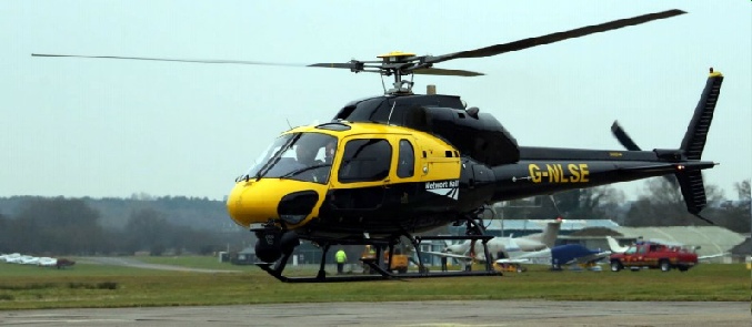
Aircraft
NR uses the Twin Squirrel helicopter. The primary one is registration number G-
Equipment
The helicopter is fitted a high definition video & infra-
Both are Giro stabilised and are fitted in the GSS Turret. This is a leap forward in technology, and was developed by Network Rail. It enables different camera payloads to be carried in a fully stabilised turret on the outside of the helicopter.
The Canon D1 stills system has lens between 85-
The Corona Discharge camera uses its thermal capacity for inspecting conductor rail systems/equipment, to identify hot spots before they become failures. Laser technology is used to pin point and fix onto equipment, for a more in depth and accurate inspection. Location details are shown on each image, which shown the exact location of that equipment/area – not where the helicopter was.
There are Satellite telephone and Airwave air-
Results
We were shown several examples photographs of work carried out. From a good view of a section of an overhead line structure, it is possible to zoom in to shown damage by overheating of a switch blade, something difficult to spot from the ground. Other views showed damaged insulators, and catenary wire stranding as it went over a pulley. Fortunately this was spotted before failure, as it would have let to a dewirement.
Comparisons
Scotland is flown every six months, along with other parts of the country, to take views. Theses are used in comparison, to spot changes in case they could case problems.
Thermal Imaging photographs are very good on third rail equipment. Examples showed how well point heaters are working (or not). Conductor rail/cable connections, insulators and hook switches all normally show a heat trace on the image. Depending on the amount of heat trace, it is possible to see failures are happening, and get maintenance staff out to rectify it, before it fails completely.
Encroachment
People extending beyond their boundary is something easy to spot from the air. We saw some photographs of a good example; about a 25 foot long, full width garden extension, with a summer house and dining area! On top of an embankment, behind some trees, it was probably unlikely to be seen from track level. When NR staff initially went to offenders like this, they use to claim it wasn’t them. So now the helicopter goes to the round to the front of the house as well to take pictures, often zooming in to get the house number. Now there’s no denying it!
Flooding -
These can be seen from the air, the examples shown were of a water-
Flooding issues
The helicopter was recently sent to the West Highland Line, when excessive rain had caused three washouts. But while investigating these, they found another one, helping shorten the time the line was shut for repairs.
An opportunist view was taken of a Chinnock helicopter, dropping bags of rocks on a river bank breach.
Flooding on the Somerset levels was measured over several days by the number of rungs visible on a signal post ladder!
Un-
Although useful, they do have their limitations. An ideally suited job was to check on the Yorkshire mining subsidence a couple of years ago. An aerial view was required at least daily, to check on the slippage. Using a helicopter would have been expensive and not practical.
Development and training on UAV’s are ongoing, they are definitely a tool of the future.
The Future – Hyperspectral Imaging
The human eye sees visible light in 3 bands, with Hyperspectral Imaging the Spectral images see many more bands, and cover a vast range of wavelengths.
Certain objects leave unique fingerprints in the electromagnetic spectrum. Examples include using a water signature to look for hidden watercourses, chlorophyll to identify ill health in trees, road condition checking asphalt. A slide showed the result of a scan of an area with Japanese Knotweed, which was able to show in detail the volume of old/new growth, old/new buds and leaves! By comparing with a later visit, you could see how the plant was growing.
It was found that the Highways Agency was also investigating the same technology, so they have teamed up with NR to develop it.
A disadvantage is it needs to be done on a clear sunny day, we don’t get many of them!
Q & A Session
- Which airports do you use?
- NR can use any airport, but prefer to use smaller ones, even the little grass strip ones! Easier to get in/out, usually friendlier, and a sale of fuel can be a welcome boost to help their survival. And a peaceful place to pop in for a cuppa!
- Do you film all the time?
- No, you look at a black and white screen whilst travelling. If you spot something then stop, fly around the defect taking photographs. They did use to film all the time, but ended up with hours of film, a huge storage issue!
- Do you do night flights?
- Yes.
After the meeting, Sean was on the Caledonian Sleeper to Glasgow. His next task was over a week’s flying across Scotland and Northern England, photographing and inspecting all the overhead line booster transformers, amongst other items.
A Lecture by Sean Leahy of Network Rail
Tuesday 1st October 2019, 55 Broadway
Written by Peter Lindop